Tuesday, September 21, 2010

Notes on driving

Driving.... That is the only bad part of this trip. But so far it has not been too bad. I have had the following major stretches of driving to do so far -

  1. Seattle WA to Yellowstone NP - 700+ miles (2 days).
  2. Yellowstone NP to Denver CO - 750 miles (2 days).
  3. Denver CO to Chicago IL - 1000 miles (2 days).
  4. Berrien Springs MI to Ithaca NY - 615 miles (1 day).
This means that I herd most of the pain to a single day of driving and then relax a bit. The bit from Denver to Chicago was bad due to Iowa and Nebraska. Come to think of it, the only good long drive has been today's to Ithaca. I saw some fall colors on the way and the lakes were beautiful. Unfortunately I didn't take too many pictures.

Driving has been made bearable by the short naps that I take in between long stretches and I have found that smaller county and state roads with 55 speed limits are better than interstates. Interstates can lead to lapses in concentration as they are monotonous and besides they have lots of trucks on them. The other concern is the Obama stimulus, which has meant lots of construction on the roads and this is very annoying esp with my manual car.

I have been reading (hearing) Bill Bryson's audiobooks. They are wonderful and are a must read for long trips like these. Another help line has been NPR and of course my crazy music which I sing along loudly.

No tickets so far, but two warnings. One was the verbal one in Oregon and another was a written one in Illinois. The cop in IL was shadowing me for a long long time. I decided to not risk overtaking (passing) the truck ahead of me, lest I creep over the speed limit and this bored cop gave me a ticket. I think he wanted to stop me for some reason to check for drugs or my immigration status or whatever. So I got closer to the truck and then braked. He pulled me over and said I was following him too close. We chatted for a while about museums etc. He was just bored and so wrote me a written warning.

Next big stretch will be from Washington to Smokies, but I will have company then. I dread driving through Oklahoma and Texas however.

Thursday, September 16, 2010

Rocky Mountain National Park 1

The Rockies are a mountain range that run from Alaska to Mexico and form the backbone of the North American continent. It also divides North America into two watersheds. If rain falls to the west of this division, called the continental divide, then it will drain into the Pacific, most likely through either the Colorado or the Columbia. A rain drop falling on the other side will end up in the Atlantic, most likely via the Mississippi/Missouri. The continental divide runs throughout the country and I crossed it numerous times in Yellowstone and Grand Tetons as well. However the continental divide is very prominent in the Rockies.

For this part of the trip, I was joined by Naresh, who flew into Denver on a Friday night and we spent the whole weekend in the park. Naresh, along with Anti has been a national park buff like me and we have been to numerous parks together. He has a acerbic sense of humor, which I quite enjoy. He and I were roommates way back in 2005 and have stayed in touch. Both he and Anti are going to join me again later in this trip towards the Smoky mountains.

When we got to the park, there was a Scottish festival going on in Estes Park, which is a city just outside the park. Possibly due to the overfill from the festival, all the campgrounds on the eastern side of the park were occupied and we had to drive through the park to the west side and we luckily found a camping site there. However the catch was that it was at around 9000 feet elevation. It was sunny most of the day and we were unprepared for the sub-zero temperatures the next morning. After warming ourselves, spotting the deer right next to the campground and gorging on ramen, we set out to do a continental divide hike.

We were hiking up to Mt. Ida, which is at a height of roughly 12900 feet. This is the highest that I have climbed to. Mt. Whitney is the tallest peak in the mainland US and it stands at around 14300 feet. I will definitely climb it one of these days. However what makes Mt. Ida unique is that the path to get there is along the continental divide. So one can claim to have traversed the middle of the US (at least a teeny tiny part of it).

Needless to say most of the hike was above the tree-line. Getting above the tree-line is a funny story. We lost the trail at the beginning itself, thanks to Naresh not listening to me. We had a topographic map of the trail and so knew the general direction to go and so we decided to freestyle climb it. It was very steep and we just climbed without thinking. I was a bit worried about getting down, but decided that it was not enough to stop us.

After got to the top, the continental divide was very easy to spot and so our trail was good from then on. We started to get going, but the winds were crazy and in spite of sunlight the windchill brought the temperature to the single digits in Celcius and the wind was drying us out. All of this made the hike a factor of two or three more difficult. However it was worth it and we took frequent breaks. Here are some photos taken while climbing.


After an arduous 5 hours, we made it to the top of Mt. Ida. When we got up there, we could see the road we drove on and a couple of gorgeous glacial lakes. These lakes were so pure that we could see their bottoms. Here are another samples of the pics.


I will talk about Moose, Elk, the Colorado and the dying pine forests in the next post. Probably will post it in Chicago. I am currently in Omaha Nebraska.

Tuesday, September 14, 2010

Yellowstone National Park 2

The next day we decided to hike around the Yellowstone canyon area. Yellowstone gets its name from the yellow stones laced with rusting Iron (not Sulfur as you would think) that can be found all over the park and which are seen in all their glory in the Yellowstone canyon. The canyon also boasts other colors of this rusting Iron in oranges, pinks etc. The colors emerge when the Iron is cooked in the hydrothermal cauldron that is Yellowstone. The canyon is made by the mighty Yellowstone river which falls into the canyon along two falls call the lower and upper falls unimaginatively.

Here are some pictures of the canyon and the falls.


Along the way, we also saw some wonderful rainbows. One was due to the mist blown by the falls and another the traditional one due to the rainy weather.

I leave you with some random photos from the park, including some of the rivers and creeks which are just lovely. I have had the privilege of swimming in these rivers, along the confluence of the hot spring water and the cold river water. Its one of those feelings that remains with you for life.


Yellowstone National Park 1

Yellowstone national park was the first national park of the United States, set up in 1872. It is the largest supervolcano in the world and is about 50 miles in diameter. The whole park is a big caldera which contains over half of all the geothermal features in the world. The NPS (National Park Service) has done a wonderful job of preserving it, while making it as accessible as Disneyland. And boy is it as much fun as Disneyland and more.

This is my fourth visit to Yellowstone and each time I go away cursing the fact that I have to leave. I come back thinking, it wont charm me this time around as much, but it never fails to work and I hopelessly fall in love with it over and over again. From a beautiful blue lake, to vivid colored springs, to gushing springs, to mud volcanoes, a spectacular waterfall into an even more gorgeous canyon, it has all the charms of a supermodel with a math PhD, who dabbles in poetry on the side.

I arrived in Yellowstone after a long drive across Washington from Seattle to Spokane and then a cut across the thin part of Idaho into gorgeous Montana. The large spaces and sparsity of people make Montana my ideal place on the planet. As the lieutenant in the movie "The hunt for the Red October", I also want to retire there far into the future. If it survives that long that is. The rate at which we are producing children, I don't think any such place will remain in my lifetime.

Any case, enough philosophizing. I know most of you just want to see the pretty pictures, so I will get on it :). This time around let me introduce a dear friend Shriharsh, who is lovingly (hatingly?) called "Anti". Don't ask why, it is not worth knowing. Needless to say Anti shares many things with me like a love for hiking and nature and an awesome sense of humor (terrible if you are not him, me or Varun).

Here he is standing next to one of the colorful springs that dot the Yellowstone landscape

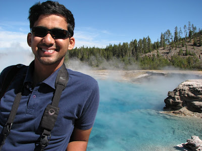
As usual he has a camera around his neck. We rely on him to not miss any important pictures and also as the whipping boy, in case we are delayed, as we can always blame the tardiness on his photography.

The first day of the trip, we decided to sight see and drive around and perhaps do a hike at the end of the day. Which is exactly what we did, albeit a bit late and had to climb down fearing for our lives singing at the top of our lungs to ward off the bears. I carry an unusually large amount of portable light with me. At last count, I had 6 different light sources, not counting my cellphone or Nintendo DS. Just in case we want to play a floodlit game of some kind.

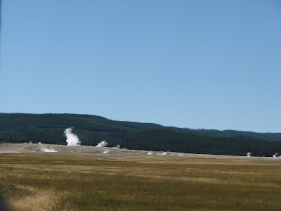
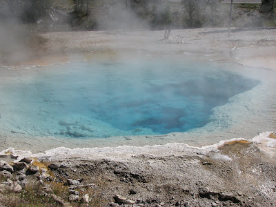
Almost any place in Yellowstone has the following landscape and a strong Sulfur smell (to those who don't know how it smells, think of rotting eggs).


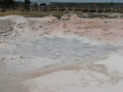
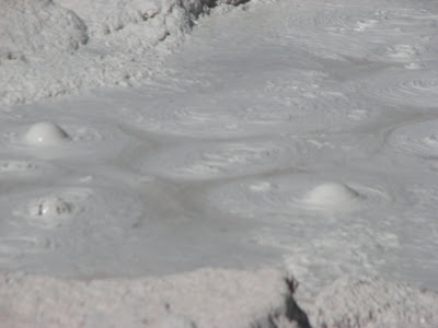
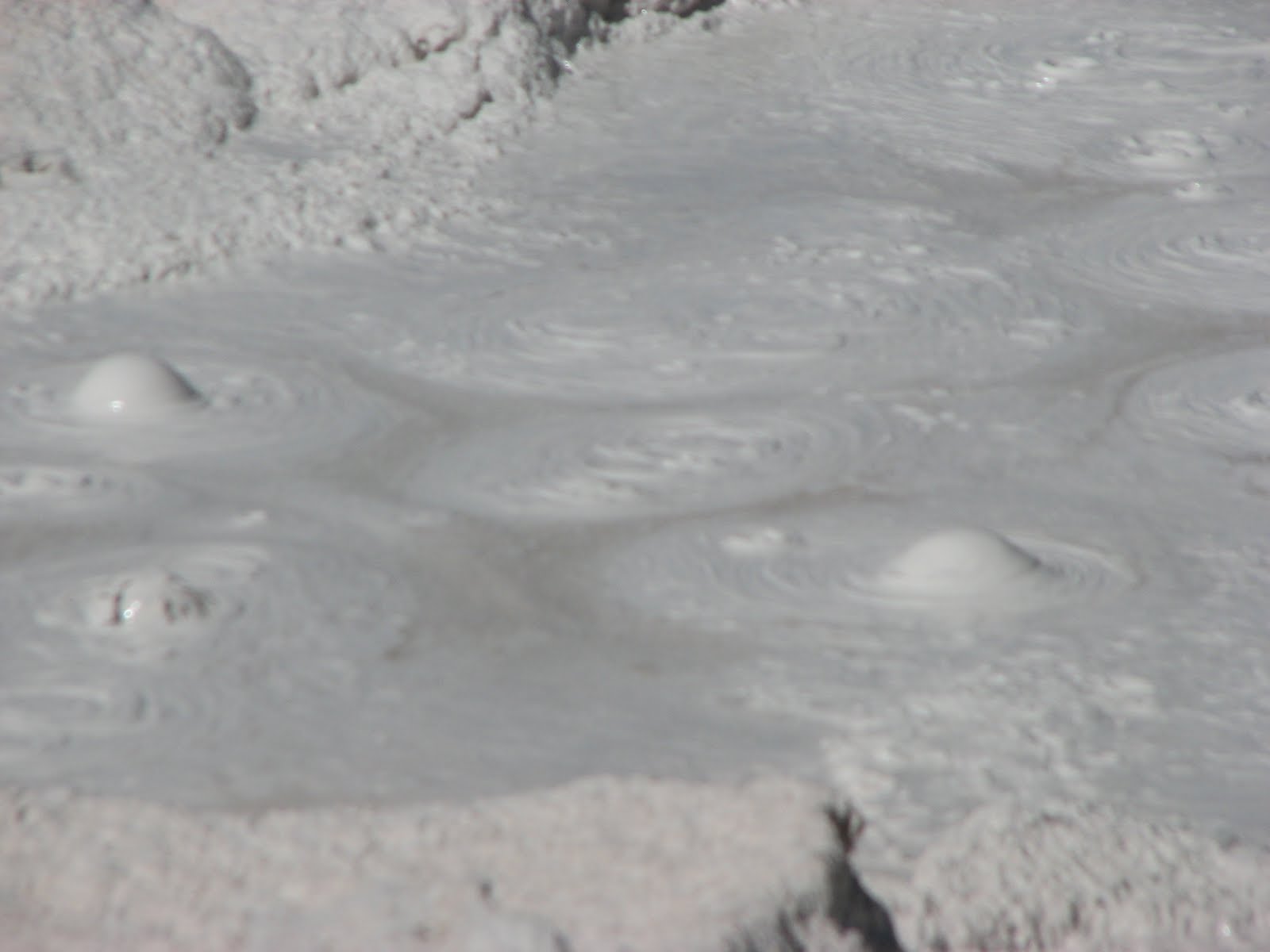
The essential force behind all these geothermal phenomenon is the awesome power of the Earth's interior. It can heat up the water and build up steam pressure, which can then come out as a fumerole (just steam), or burst out as a geyser, like the famous Old Faithful geyser, or it can form an interesting phenomenon called a paint pot, which is acidic mud over which the steam bubbles over.


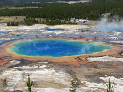
The kings are of course the springs, with the Emperor being the grand prismatic spring. Here are the photos of the springs up close and from a nearby hill.


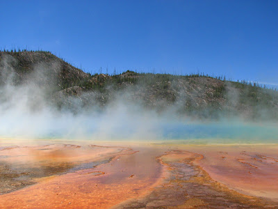
The last picture was taking through a sunglass and it shows how much difference polarization makes. Most of the reflected light is polarized and the sunglasses cut out this reflected light significantly.

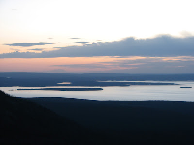
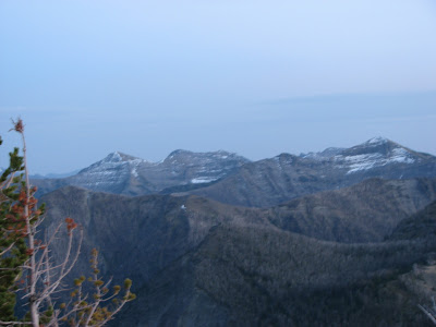
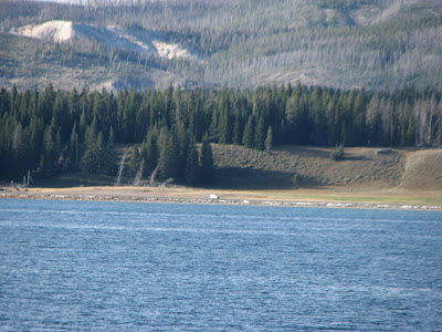
In the evening we had a wonderful hike on a mountain near the Yellowstone lake. The sunset was beautiful and we saw some lovely peaks.

Monday, September 6, 2010

Seattle and PAX

I was in Seattle for four days. There was an event going on in Seattle called the Penny Arcade Exposition (PAX), which was the reason why Jeff had joined me on the trip. Harmony was tagging along because she has relatives in the area and because she has good company on the trip.

The first day we spent roaming around Seattle, had lunch with Evan (a LIGO colleague and a good friend from the Hanford days). We then took the customary Space Needle tour and boy was it worth it this time around. Here are some of the breathtaking sights I got to see from top the needle. It is none other than the Queen of all National Parks Mt. Rainier.


We fooled around on top and I took my fill of Rainier, spotted a water plane land etc. I even took a picture of Mt. Baker, Mt. Rainier's smaller cousin.


We then headed to the Pike place market, which has a variety of hawkers and food stalls selling all sorts of stuff. I bought some raspberry habanero jam, which was delicious and is still going. At some point Jeff strolled into a bookstore with a charming clerk who told us about the free day at the Seattle Art Museum (disturbingly acronymed SAM). SAM was strictly ok, too much modern art and very little of the real kind (my real kind anyways).


PAX was a lot of fun, but also a lot of work in terms of standing in line. The total number of people attending has been a number that has changed depending on whom you ask, but I will stick to the original estimate of around 40000. This was the largest collection of geeks and nerds on the planet (save NASA perhaps). People wore crazy dresses from Star Wars themes to Halo to every single thing you can imagine. There were game enthusiasts from PC games to consoles to table top games like Settlers of Catan etc. Here are some of the pictures I took while at PAX. Featured are cool gadgets like the touch table that was used to play Settlers on and things like Microsoft's Kinect, which has a camera that reads your intentions and then plays the game accordingly. We tried playing tennis with it and it worked out well (I beat Jeff 3-0, so I suppose it works just fine ;) ).


Portland

Time to introduce Harmony, she is my ex-roomie from about Feb 2009 to Nov 2009. She is a chemical engineer from Caltech and we (Jeff and I) call her 'Master Engineer'. She works in Orange county and has a real job trying to keep smog from ruining our lives. Here is she holding donuts from a crazy donut shop in Portland called Voodoo donuts.
The big donut is predictably Jeff's and they both struggled to finish it, much to Harm's chagrin. After the donut run, we went to see the famous Portland Chinese gardens, which were essentially made in Suzhou China and are classical scholarly gardens, which are ancestral in origin and are maintained through the generations as a show of scholarly and monetary prowess.

The gardens were gorgeous. Here are some photos.


We topped the day off with a visit to the bar at the 30th floor of a Portland building. However the day was cloudy and so no great view of Mt. Hood was there to be taken.